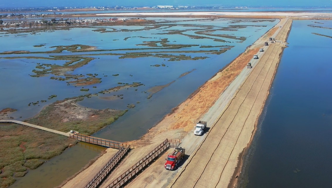
Hoping to reduce flooding risk for thousands of people living in low lying areas and expand habitat for fish and wildlife, Silicon Valley’s largest water agency and the U.S. Army Corps of Engineers on Thursday announced they have completed a $197 million project to build two miles of new levees along San Francisco Bay’s southern shoreline.
The new 15-foot-high clay and dirt structures stretch from Alviso Marina County Park to the Don Edwards San Francisco Bay National Wildlife Refuge Environmental Education Center.
They are designed to protect homes and businesses against the type of winter storms that have severely flooded the low-lying community of Alviso multiple times with water up to 6 feet deep and which are posing more risk as sea level rises due to climate change.
“I lived through the floods of the 1950s, 60s 1983 and 1995,” said Dick Santos, an Alviso native who serves as vice chairman of the Santa Clara Valley Water District. “Not just the water, but the damage, the destruction and fear. That’s why this project means so much to me. I lived it.”
The work, officially called the South Bay Shoreline Project, also is the key step toward plans for restoring 2,900 acres of former Cargill industrial salt evaporation ponds near Alviso back to tidal wetlands for fish and wildlife, and to expand waterfront public trails in the South Bay, officials said.
“In a region of 8 million people, the national wildlife refuge offers something rare: solitude, wonder and connection,” said Chris Barr, deputy manager of the San Francisco Bay National Wildlife Refuge Complex, a 55,000-acre collection of seven wildlife refuges around the Bay Area.
A heron at the Alviso Unit of the Don Edwards San Francisco Bay National Wildlife Refuge on Thursday, Sept. 25, 2025. (Aric Crabb/Bay Area News Group)
The new levees will replace old dirt berms that are 6 to 10 feet high. They will offer more protection from flooding for areas in Santa Clara County north of Highway 237, including key facilities such as the region’s wastewater treatment plant, rail lines and the homes of 5,500 people.
Thursday’s completed 2-mile section will be expanded eastward to build another 2 miles of new levees from the Don Edwards education center near Artesian Slough to Coyote Creek. Construction is set to begin on that part in 2028, after permits are approved, and funding and easements are secured, said Matt Keller, a spokesman for the water district. Total cost for all 4 miles: $545 million.
So far, the project has received $124 million under a bill approved by Congress in 2018. The water district, also known as Valley Water, provided $15 million from the 2012 Safe, Clean Water Program, a parcel tax approved by voters in 2012. Another $61 million came from Measure AA, a $12-per home tax approved by voters in 2016 in all nine Bay Area counties for wetland restoration and flood control. In addition, $15.1 million came from the state Coastal Conservancy. The water district said it expects additional funding to come from state and federal flood programs.
Low-lying areas around the bay have always been at risk of flooding in big winter storms. Sea level rise is increasing the threat.
San Francisco Bay has risen by 8 inches in the past 100 years, according to the tidal gauge at Fort Point under the Golden Gate Bridge and other instruments. As the planet continues to warm, melting ice caps and expanding the volume of sea water, scientists project bay waters will rise nearly another foot by 2050 and 3 feet or more by 2100, depending on how much emissions of fossil fuels rise or fall over the next 75 years worldwide.
“We’ve built megacities of the world on coasts,” said Gary Griggs, a distinguished professor of earth sciences at UC Santa Cruz, in 2022 when the Alviso project broke ground. “We didn’t think of sea level rise 100 years ago, and now we are having to pay the price. Whether it is Jakarta, or Miami or San Francisco, they all have the same problems.”
The Alviso project is the latest attempt by Bay Area planners to deal with rising waters.
Others include a $5 billion project to rebuild the massive seawall along San Francisco’s Embarcadero from Fisherman’s Wharf to the Giants ballpark, where flooding is increasingly common during big storms; a $587 million project to build higher levees around San Francisco International Airport to keep the runways from flooding during high tides and storms; and a proposal to raise Highway 37 in the North Bay that could cost $6 billion or more.
The Alviso project has faced challenges, including cost overruns and delays.
It was first envisioned in 2005 when the Army Corps and the Santa Clara Valley Water District began planning. Former Sen. Dianne Feinstein, who brokered a $100 million deal in 2003 for the federal and state governments to buy 16,500 acres of former salt ponds from Cargill Salt to restore wetlands across the South Bay, championed it.
Thursday’s 2-mile section was supposed to be finished by January 2024. But winter storms and other delays set the completion date back, water district officials said.
The project is a partnership between the Army Corps, the Santa Clara Valley Water District and the state Coastal Conservancy. Planning is underway for Phase 2 and Phase 3, which eventually will provide similar flood protection north to Sunnyvale, Mountain View and Palo Alto sometime after 2030, likely at a cost above $1 billion.
“There’s a lot more work to be done,” said Lt. Col. Virginia Brickner, with the U.S. Army Corps of Engineers.
A pair of bird watchers scan the New Chicago Marsh at the Alviso Unit of the Don Edwards San Francisco Bay National Wildlife Refuge on Thursday, Sept. 25, 2025. (Aric Crabb/Bay Area News Group)