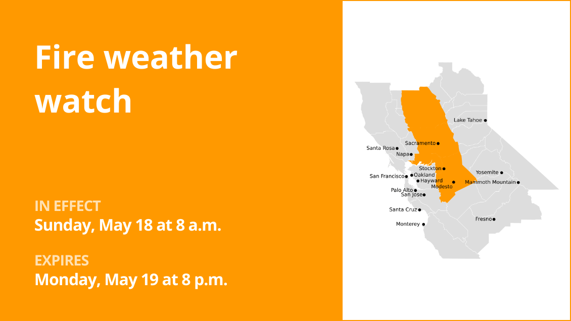
Portions of the North Bay and the East Bay could be at a greater risk for grass fires Monday, as a ridge of high pressure brings warm temperatures and dry winds to the region.
The Altamont Pass — along with most other areas above 1,500 feet across the East Bay and the North Bay, including the Mount Saint Helena region — are expected to face an elevated fire threat Monday, according to the National Weather Service. Humidity levels should drop to 25% to 35% in those areas, while winds could gust to 25 to 35 mph, said Roger Gass, a weather service meteorologist.
Related Articles
Why climate risk could affect your credit score for buying a home
For Bay Area, a steady run of warmer temperatures, clear skies is around the corner
Bay Area weather: How unusual is rain in May?
Warm spring week forecast in Bay Area to follow drizzly Monday
Live map: Where it’s raining in the Bay Area
Further east, meteorologists issued a red flag warning for much of the Central Valley, suggesting that area is particularly susceptible to wildfire. The greatest threat is grass fires, as most of the region’s trees continue to hold moisture from this past winter’s storms.
Already on Sunday, a grass fire south of Brentwood scorched 51 acres Sunday afternoon. The blaze, which began near Walnut Boulevard and Camino Diablo, was 80% contained Monday morning as crews continued to douse hot spots. No one was injured and no structures were damaged, and investigators are still investigating how it started.
The fire concerns come as a ridge of high pressure builds in from the Pacific Ocean, raising temperatures and drying out the landscape. High temperatures on Monday will be in the low-80s in San Jose, as well as much of Contra Costa County. Meanwhile, Oakland should reach 78 degrees, while San Francisco should get to 72 degrees.
“We’re in between seasons – we’re not quite into fire season, but it’s quickly approaching, as these warm temperatures and low humanities start to continue to dry out the fuels,” Gass said.
Temperatures should dip a few degrees Tuesday before rising again on Wednesday — all before a trough of cool air swoops into the region Wednesday night, bringing slightly cooler conditions. Winds should ease beginning Tuesday, lessening the fire danger.
Conditions should continue to be dry, however, with no rain forecast to fall throughout the week.
The Santa Clara Valley should recede back into the 70s by the end of the week, along with most cities across Contra Costa County. In Oakland and San Francisco, temperatures should drop into the 60s by that time.