If you look at a map of Lake Berryessa, a 23-mile-long body of fresh, blue water in the mountains east of Napa Valley, you’ll notice that its 165 miles of shoreline are jagged, broken up with with deep, meandering inlets and island archipelagos.
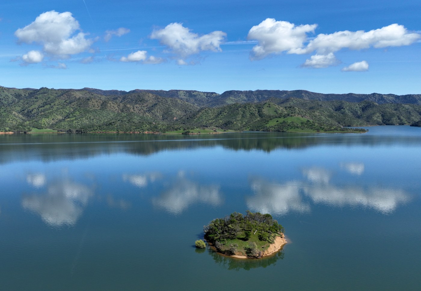
Those strings of islands include tiny, hump-backed Goat Island, which used to be a small hill overlooking the former Berryessa Valley. Up until the 1950s, this valley was an agricultural jewel, home to rich soil, family farms, orchards, a famous stone bridge, Putah Creek and the small town of Monticello.
A drone view of Goat Island on Lake Berryessa in unincorporated Napa County, Calif., on Tuesday, March 18, 2025. (Jane Tyska/Bay Area News Group)
Then came the water – more than a million acre-feet filling the basin over the course of several years after the Monticello Dam was completed in 1957. This massive inundation wiped out a thriving community and one-eighth of Napa County’s farmland, though it created a new reservoir with remarkable new topography and beauty.
Many people visit Berryessa for boating, fishing, picnicking or swimming. They hike in the surrounding mountains or drive up Highway 128 from Winters to gaze into the maw of the Glory Hole – an engineering feat near the 304-foot-tall dam. It’s a circular spillway that drains the lake when the water level reaches 440 feet.
A view of the Glory Hole spillway at the Monticello dam in Lake Berryessa, Calif., on Tuesday, March 18, 2025. It experienced its first spillover since 2019. (Jane Tyska/Bay Area News Group)
But visitors might not be aware of the lake’s unique history and that its waters now cover the location of a former town. It was such a mind-boggling concept in the 1950s that famed photographer Dorothea Lange and her assistant, Pirkle Jones, traveled to the valley multiple times to document its extinction. If nothing else, Goat and the other islands in the lake serve as reminders that the scenery here once looked very different.
A first-time visitor also may be surprised that Lake Berryessa feels so remote and that public amenities are limited, even though it’s less than an hour’s drive from Winters or Napa Valley. All roads leading to the lake wind around hills and peaks of sometimes harsh, rugged beauty. There’s the Cedar Roughs National Wilderness to the west and oak- and manzanita-covered hills, rising to 3,060-foot Berryessa Peak, to the east. In August 2020, an unprecedented lightning storm sparked a devastating fire in the tinder-dry hills that raged down to the lake and devastated much of the Spanish Flat neighborhood on the lake’s western shore and an additional 100 homes in another part of the lake.
A view of the destroyed Spanish Flat Mobile Villa trailer park in Lake Berryessa, Calif., on Thursday, Aug. 27, 2020. The Hennessey Fire, part of the LNU Lightning Complex Fire, tore through the area on Aug. 18. (Jane Tyska/Bay Area News Group)
Peter Kilkus, the Lake Berryessa News‘ publisher, has described the area as marked by a series of tragedies, even before the 2020 LNU Lightning Complex fires. Some may vaguely remember that the Zodiac killer targeted two of his victims on a tiny spit of land — a landform that turns into yet another island when the lake’s water level rises during winter rains.
Related Articles
4 of the Bay Area and Northern California’s odder islands
5 Bay Area island wine tasting rooms, beer gardens and distilleries to try
Behind the extraordinary growth of Alameda Island, the Bay Area’s first suburb
With two new apps guiding visitors to scenic views, Angel Island is ‘one of the best kept secrets in California’
Navy subs, nuclear secrets and beer: The riveting history of Bay Area’s Mare Island
To Kilkus, the first tragedy was the destruction of Native American culture. For thousands of years, hunter-gatherer groups thrived in the rich natural environment of Berryessa Valley. But after European contact, they were driven out by settlers, sent to California missions or killed by smallpox or other diseases.
The second tragedy, he writes, was the destruction of Spanish culture after California was ceded to the United States in 1848. Still, Kilkus points out, the valley gets its name from two Mexican brothers, Sisto and Jose Berryessa, who received the valley from a land grant from the Mexican government.
Debts eventually forced the Berryessa brothers to sell off much of their property. New settlers included farmers, ranchers and small-town businessmen, who transformed the valley into a prosperous agricultural community. “The valley itself was flat and fertile and was considered to have some of the best soil in the country,” Kilkus writes.
Established in 1867, Monticello had at most 300 residents during its nearly 90-year history. Still, at various times, it supported a hotel, a school, a bar and general store. People would catch up on community gossip at the store or gather in town for rodeos, baseball games and “cow roasts.”
Dorothea Lange photographing the destruction of a California landmark, Berryessa Valley. All trees are cut to within six inches above the ground, from “Berryessa Valley — The Last Year” (Pirkle Jones)
Tom Gamble, who owns Oakville’s Gamble Family Vineyards, says his family began farming in Napa County in 1916. Gamble is a descendant of James Gamble, co-founder of Procter & Gamble, and related to the Gamble family of Palo Alto. But the pride and joy of his grandfather, Launcelot Gamble, were the tracts of ranch and farmland he pulled together in the Berryessa Valley, including 3,000 acres on the valley floor. “My grandfather spent his life putting that ranch together,” Gamble says.
All that began to end after World War II with what Kikus calls a third tragedy: the destruction of rural culture in Berryessa Valley.
America was still in its era of large-scale dam building, and officials in Solano County and the federal government wanted to find a reliable source of water for booming Solano County agriculture and Cold War-era military bases, including Travis Air Force Base. So they focused on a plan to capture the water of Putah Creek in a reservoir by constructing a massive dam across Devil’s Gate, a steep, rocky gorge at the southeastern end of the valley.
Gamble’s grandfather was among the valley residents who traveled to Washington to protest the dam’s construction, in part because the new reservoir’s water would only go to Solano County. But it was all for naught. Ground was broken for the dam in 1953. Photos by Lange and Jones show how the valley was prepared for inundation: Homes, barns and other structures were torn down, burned or removed. Trees and other vegetation were chopped down to within six inches of the ground. Even the graves at the town’s cemetery were exhumed and moved to higher ground near Spanish Flat.
The Monticello Cemetery in unincorporated Napa County, Calif., on Tuesday, March 18, 2025. All of the graves were dug up and moved in the late 1950s to make way for Lake Berryessa. (Jane Tyska/Bay Area News Group)
Tom Gamble has mixed feelings about the lake. Born after its creation, Gamble grew up on his family’s land in the Napa Valley and their ranch along the lake’s eastern shore. The inundation was “a big challenge” for his grandfather and his father, George.
“It was disheartening to be displaced and see your life’s work go up in smoke,” Tom Gamble says.
But he also recalls having “a lot of fun” on the lake as a teenager, where water temperatures reach 75 degrees in the summer. His experience with the lake also helped inform his lifelong passion for environmental preservation. He loves hiking in the nearby hills and spotting the variety of birds and other wildlife the lake attracts. He notes that the lake sits at the southern end of the Berryessa Snow Mountain National Monument, a network of wildlands that reach into Mendocino County and provide an important wildlife corridor.
“You can go out there on a January day and see up to 70 species of birds,” he says. “And there’s this whole dichotomy of hiking in the dry hills in the summer and looking up to see white pelicans circling overhand. Where in a traditional rolling California landscape are you going to see a bird like that?”
A drone view near the Oak Shores Day Use Area at Lake Berryessa in unincorporated Napa County, Calif., on Tuesday, March 18, 2025. (Jane Tyska/Bay Area News Group)
If you go
Public access to the lake is limited to day-use areas managed by the U.S. Bureau of Reclamation on the western shore. Several private concessionaires operate marinas, with slip and boat rentals, tent and RV camping and cabin rentals. Find details at www.usbr.gov/mp/ccao/berryessa/visitor-info.
Dining options are limited, but Rhonda’s Roadhouse opened late last year in Spanish Flat, serving burgers and barbecue fare on Fridays and weekends at 4310 Knoxville Road, Napa; 707-492-7028.
For more travel coverage in the Bay Area and beyond, follow us on Flipboard.